HIM model can rapidly forecast flood depths for urban areas
Taiwan is located in the northwestern Pacific Ocean, where typhoons are common, with an average of 3.4 typhoons making landfall each year. Since 2000, the frequency of typhoons has increased from once every three or four years to once a year. This not only affects people's lives and property, but also has a serious impact on Taiwan's industrial and economic development. In recent years, climate change has led to the frequent occurrence of extreme events of short-duration heavy rainfall. Flooding events such as levee overtopping have become rare, replaced by rapid flooding caused by short-duration, high-intensity heavy rainfall. When rainfall exceeds the design capacity of drainage systems in urban areas, flooding occurs that can disrupt human life or cause severe loss of life and property. To mitigate the effects of flooding, structural and non-structural measures must be combined to maximize the benefits of disaster mitigation and prevention. Flood warning systems are one of the most widely used and effective non-structural measures. The response time to extreme events is getting shorter and shorter and the flood modeling in the system needs to be faster and faster.

This study integrates a Digital Elevation Model (DEM) and a Cell Autonomous (CA) model to develop a customized model for rapid assessment of urban flood risk. Flood models generally use Shallow Water Equations (SWEs) to simulate the propagation of flood waves. When an SWEs-based flood model is used to simulate a large area or high-resolution terrain, it requires more computational resources (e.g., parallel computing, high-performance computing cores, GPUs). Otherwise, the time required for model computation cannot meet the needs of emergency response operations. In this regard, many studies have simplified SWEs or adopted different governing equations, such as conservation of mass, Manning's formula, or Manning's formula to efficiently evaluate the risk of flooding in an urban area.
Dottori and Todini (2011) first proposed to develop a fast flood model based on the concept of cellular automata (CA), which can significantly speed up the computation speed, but for high-resolution numerical terrain (e.g., 2 m or finer), the CA model still requires a longer computation time. Some studies have begun to use a Digital Elevation Model (DEM) as a basis to utilize the elevation difference generated by the terrain to transmit and disperse the flood water. The DEM model is assumed to take advantage of the characteristics of water flowing from the higher to the lower part of the terrain, and any inundation will fill the so-called terrain depression before continuing to the next place, this theory is called flat-water assumption. This type of inundation model driven by numerical terrain differences is fast and stable because it does not need to solve the complicated momentum equation, but only the conservation of mass.
The disadvantage is that it cannot provide the temporal evaluation of the flooding process. In this study, we propose to integrate CA and DEM to develop a two-dimensional hybrid inundation model (HIM).
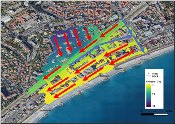
The results shown above are for the 2014 flood event in Nice, France. Overall, only about 2% of the total rainfall was discharged into the drainage system, a finding similar to this study, which was also found in the paper by Salvan (2017). Furthermore, the HIM model simulation shows that the main problem causing the disaster in this area is the difference in the direction of the surface water flow and the drainage system flow.
In the figure above, red is the direction of surface water flow and blue is the direction of drainage flow. The result shows that the drainage system flows from the west to the east of the area, while the surface water flows in the exact opposite direction. In addition, the drainage system covers only a small portion of the urban catchment area, so to improve the flooding problem, more pipes are needed to intercept surface water in order to minimize flood damage in the area.